
Every photo you take quietly records where you were, when you were there, and what device you used — and anyone you send the original file to can read all of it. Our free EXIF Viewer, Editor & Remover shows you that hidden data, lets you correct it or add a location on a map, and strips it completely before you share. It handles up to 100 photos at once, each on its own editing card, and it runs entirely in your browser: your photos are never uploaded anywhere.
Most people know this kind of tool as a viewer — GeoImgr made the idea familiar: drop in a photo, see its metadata, check the map. This one starts there and keeps going. Viewing is only the first of its three jobs; it also edits the descriptive fields viewers leave read-only (title, tags, camera, artist, copyright), and it verifies its own work by re-reading every file it saves, so the badge on a card is what is actually stored in the file — not what the tool hopes it wrote.
What EXIF data is, in plain terms
EXIF is a block of text data that cameras and phones embed inside a photo file at the moment of capture. It sits alongside the pixels, invisible in normal viewing, and travels with the file wherever the original goes — email attachments, marketplace uploads, shared drives, client handovers. The categories in a typical photo:
| Category | What it contains | Why you might care |
|---|---|---|
| Location | GPS latitude, longitude and altitude, often accurate to a few metres | Can reveal a home address, a child's school run, or where stock is stored |
| Camera & lens | Make, model and sometimes serial-level detail | Shows exactly what equipment you own |
| Exposure | Shutter speed, aperture, ISO, focal length | Useful for photographers learning from their own shots |
| Dates | Date and time taken, and modified | Can contradict a listing, a claim or a story |
| Identity & rights | Artist, copyright, description, tags | The fields professionals use to keep credit attached to their work |
| Technical file data | Dimensions, resolution, colour profile, thumbnail data | Mostly harmless — but it is still part of the record |
The detail people miss: large social platforms usually strip this data when you upload. Marketplaces, forums, email and file-sharing often do not — they pass the original file through intact. That is why cleaning a photo yourself, before it leaves your device, is the only reliable option.
The tool at a glance
Open the EXIF Viewer, Editor & Remover and you get a map on the left, an upload panel on the right, and the batch controls underneath. Drop in one photo or a whole folder's worth (up to 100). Each photo becomes its own card showing a GPS badge if it carries a location, its dimensions and its date — with an edit form pre-filled from the photo's own values.
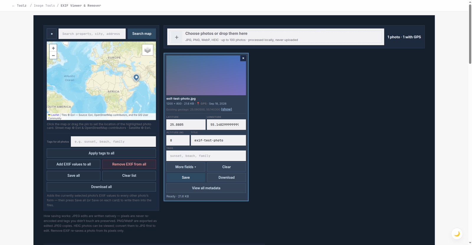
The test photo loaded: the map pin sits on its recorded GPS position, the card is badged "GPS", and the edit form is pre-filled with the photo's stored coordinates, ready to correct.
I tested it with a photo whose data I already knew
Tool claims are easy to write, so I built a test photo with metadata I set myself in advance — a Canon camera identity, a GPS fix near Dubai Marina, a September date, specific exposure settings and a named artist and copyright — and ran it through the viewer. Everything I had planted was found and displayed correctly:
| Field I set | What the tool displayed |
|---|---|
| Camera make / model | Canon / Canon EOS R6 |
| GPS position | 25.080500, 55.140300 — flagged with a warning banner and a pin on the map |
| GPS altitude | 8 m |
| Date taken | 18 September 2026, 5:42:10 PM |
| Exposure | 1/250 s, f/2.8, ISO 200, 35 mm focal length |
| Artist / copyright | Test Photographer / Test Studio 2026 |
| Description | Shown in full, exactly as written |
| Dimensions / size | 1200 × 800 px, 21.6 KB |
One deliberately simple test file produced a properties table of roughly two dozen rows. A real phone photo typically carries 40 or more properties — the same groups, more of them:
Properties found in my single test photo, by group — hover or tap each bar for details.
Viewing: the full record, with the location called out
"View all metadata" on any card opens the complete properties table — camera, lens, exposure, dates and the technical rows — read from EXIF, IPTC, XMP, ICC and the file headers. If the photo carries GPS coordinates, the table opens with a plain warning — "This photo contains GPS location" — with the coordinates and a map link, so the one field that can actually expose you is never buried in row nineteen.
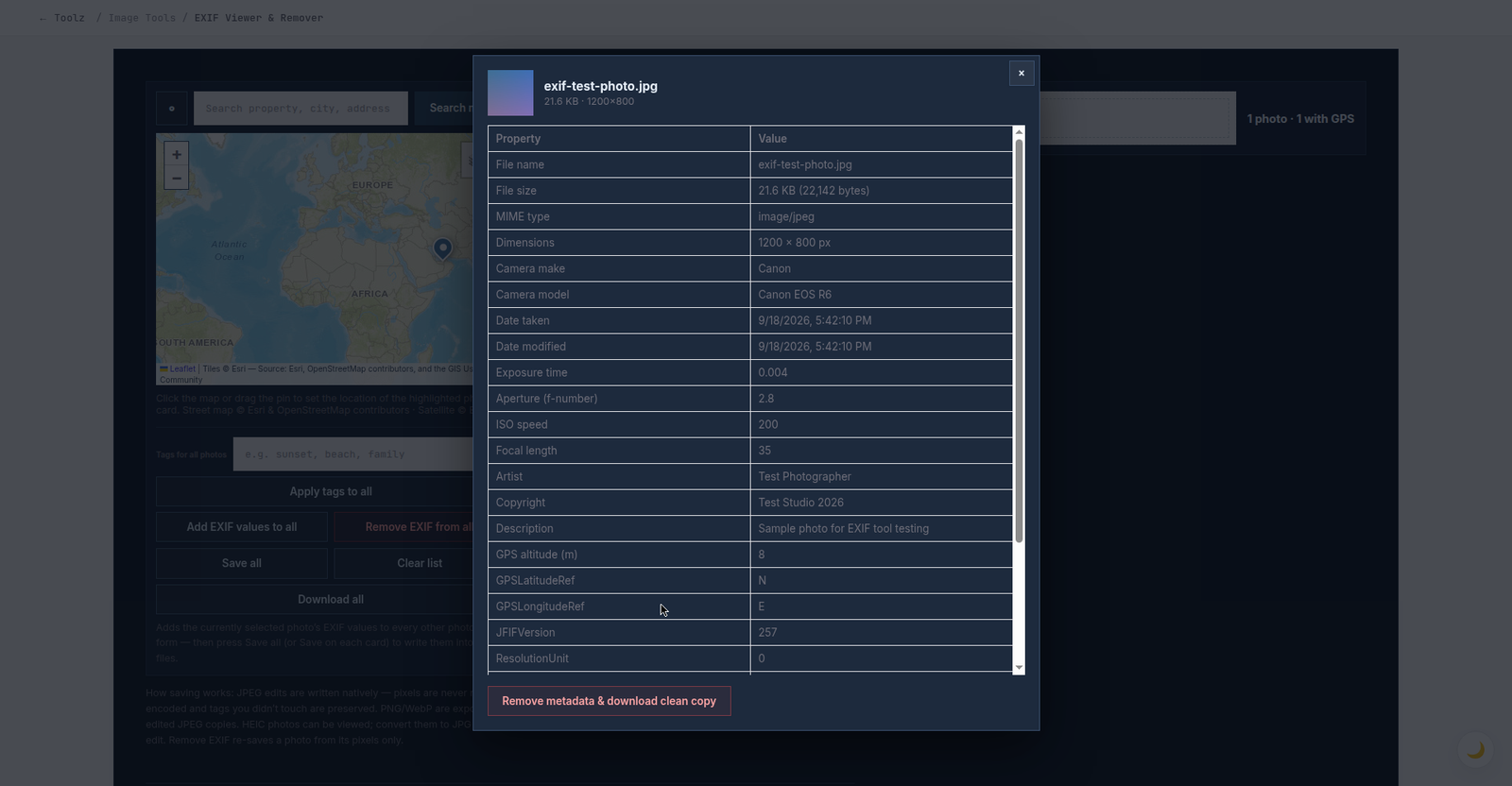
The complete record for one photo — every property the file carries, in one table.
Editing and geotagging: each photo keeps its own card
This is where the tool leaves simple viewers behind. Every photo's card carries its own form — latitude, longitude and altitude, title, tags, and under "More fields", camera make and model, artist, copyright and description — pre-filled with that photo's existing values. Change what you need and press Save on that card. Three details matter:
- JPEG edits are written natively. The new values are merged into the file's metadata segment; the picture pixels are never re-encoded, and tags you did not touch are preserved. Your image quality cannot degrade from an edit.
- Geotag by map, not by memory. Click a card to make it the map's target, then click the spot, drag the pin, or search for a place by name. Photos from a camera without GPS — a whole holiday folder, say — can be placed properly in minutes.
- Batch honestly. Set the location once on one card, use "Add EXIF values to all" to fill every other card's form, then "Save all". Tags work the same way with "Apply tags to all". Finished photos download individually, or together as one ZIP with "Download all".
Removing: the strip test
The same photo went through "Remove metadata & download clean copy". The tool re-saves the photo from its pixels only — EXIF, GPS, XMP and thumbnail data are simply not carried across — then re-reads the result and reports it verified. My test file came back at 11.0 KB against the original 21.6 KB (the drop is the removed data plus one high-quality re-encode), still 1200 × 800, visually identical — and its metadata table now contains nothing but file-format rows: no camera, no date taken, no GPS, no artist, no description. The card badge flipped from "GPS" to "No GPS", and the batch equivalent, "Remove EXIF from all", does the same job for a whole folder in one pass — the workflow a marketplace seller photographing stock at home actually needs.
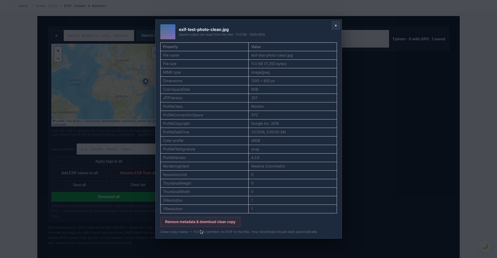
After cleaning: only file-format rows remain, and the tool states the result plainly — "Clean copy ready — verified: no EXIF in the file."
Formats, and how saving really works
| Format | View | Edit / geotag | Remove |
|---|---|---|---|
| JPEG | Yes | Yes — written natively, pixels untouched | Yes — re-saved from pixels, verified |
| PNG / WebP | Yes | Yes — exported as an edited JPEG copy, labelled on the card | Yes — same export path |
| HEIC | Yes | Convert to JPG first (our HEIC to JPG Converter does it in your browser too) | Same — convert first |
Two honesty notes. The clean copy re-encodes a JPEG once at high quality — visually indistinguishable in normal use, but keep your originals if you need bit-perfect archives. And metadata some other app keeps in a separate sidecar file next to the photo is not part of the image, so no image tool can change it. If stripped photos are part of preparing product images for a store, the companion guide is our online store product photo guide; if file size is the battle instead, start with the image compression guide.
More new tools on the tools page
The EXIF tool is the headline of a bigger build-out: the tools page has grown to 91 free tools. The other recent arrivals worth knowing about:
| New tool | What it does |
|---|---|
| Image to Text (OCR) | Extracts the text from images and screenshots |
| Compress Image to Exact KB | Shrinks a photo to a precise target size for upload forms with KB limits |
| Video Compressor | Compresses MP4, MOV and WebM in your browser |
| Video to GIF Converter | Turns video clips into animated GIFs |
| Bulk Meta Extractor | Pulls titles and descriptions from many pages at once |
| Bot Viewer | Shows any page the way a search bot reads it |
| Robots.txt Generator | Builds crawler rules visually instead of by syntax memory |
| Sitemap Generator | Crawls a site and builds its XML sitemap |
| XML Sitemap Extractor | Pulls every URL out of an existing sitemap |
| JSON Formatter & Validator | Formats, minifies and checks JSON |
| Domain Separator | Cleans domain lists out of messy pasted text |
| Ultimate URL Editor | Edits a URL part by part, safely |
| HTTP Status & Redirect Checker | Traces any URL hop by hop through its redirects |
| Compress PDF, Merge PDF, Split PDF | The PDF set grows from one tool to a full trio |
Five EXIF mistakes to stop making
- Emailing originals and assuming they arrive cleaned. Email does not strip metadata. If the photo was taken at home, its GPS fix goes with it.
- Geotagging your own address into listing photos. Adding location is a feature — pointed at the wrong place, it publishes where your stock, or your family, sleeps.
- Trusting that "the platform handles it". Some do, many do not, and policies change. Cleaning the file yourself takes seconds and works everywhere.
- Deleting originals after cleaning. The clean copy is for sharing; the original, with its full record, is your archive and sometimes your proof of authorship.
- Stripping the copyright fields from your own professional work. Removal is for privacy-sensitive sharing. For portfolio and client work, the artist and copyright fields are exactly what you want travelling with the file — edit them in, do not delete them.
Frequently Asked Questions
What is EXIF data?
Metadata cameras and phones embed in photo files: device model, lens and exposure settings, date and time, and frequently GPS coordinates accurate to a few metres. Anyone you send the original file to can read it — which is why viewing it yourself first is worthwhile.
Is my photo uploaded to a server for analysis?
No. Reading, editing and cleaning happen locally in your browser, and your photos — and their locations — never leave your device. The only thing ever sent anywhere is the text you type into the place search, which goes to a map search service to find the place; no photo data is included.
Does editing a photo's EXIF damage its quality?
Not for JPEGs. The editor writes the metadata segment directly into the file and leaves the compressed image data untouched, so quality is identical and tags you did not edit are preserved. Only the remover, and the PNG/WebP export path, re-encode — at 92% quality.
Can I add a location to photos that have none?
Yes — that is what each card's form and the map are for. Highlight the photo's card, click the spot on the map (or search for the place by name), and press Save on the card. The coordinates are written as standard GPS EXIF tags, so maps and photo apps place the photo correctly — and the card's badge is re-read from the saved file.
Does removing metadata change how the photo looks?
No. The pixels are preserved at full resolution; JPEG output is re-encoded at 92% quality, which is visually indistinguishable in normal use. Only the hidden data segments are removed — and the tool verifies the clean file by re-reading it before calling it clean.
Can I process many photos at once?
Yes, up to 100 per batch. Each photo keeps its own card and values; share one location or tag set across the batch with the apply-to-all controls, save everything with "Save all", strip everything with "Remove EXIF from all", and download the results together as one ZIP.
What about HEIC photos from an iPhone?
They can be viewed here. To edit or strip them, convert to JPG first — our free HEIC to JPG Converter runs in your browser the same way — then bring the JPG back here.
Check one of your own photos before you share it next: open the free EXIF Viewer, Editor & Remover, drop the photo in, and see exactly what it has been saying about you — then fix it, geotag it, or strip it, in the same place.
Building a website or store where product photos, privacy and presentation are handled properly from day one? Book a free consultation — we set up the image workflow along with the site, so your team is never guessing about sizes, formats or metadata again.
Be the first to share a useful question or thought.